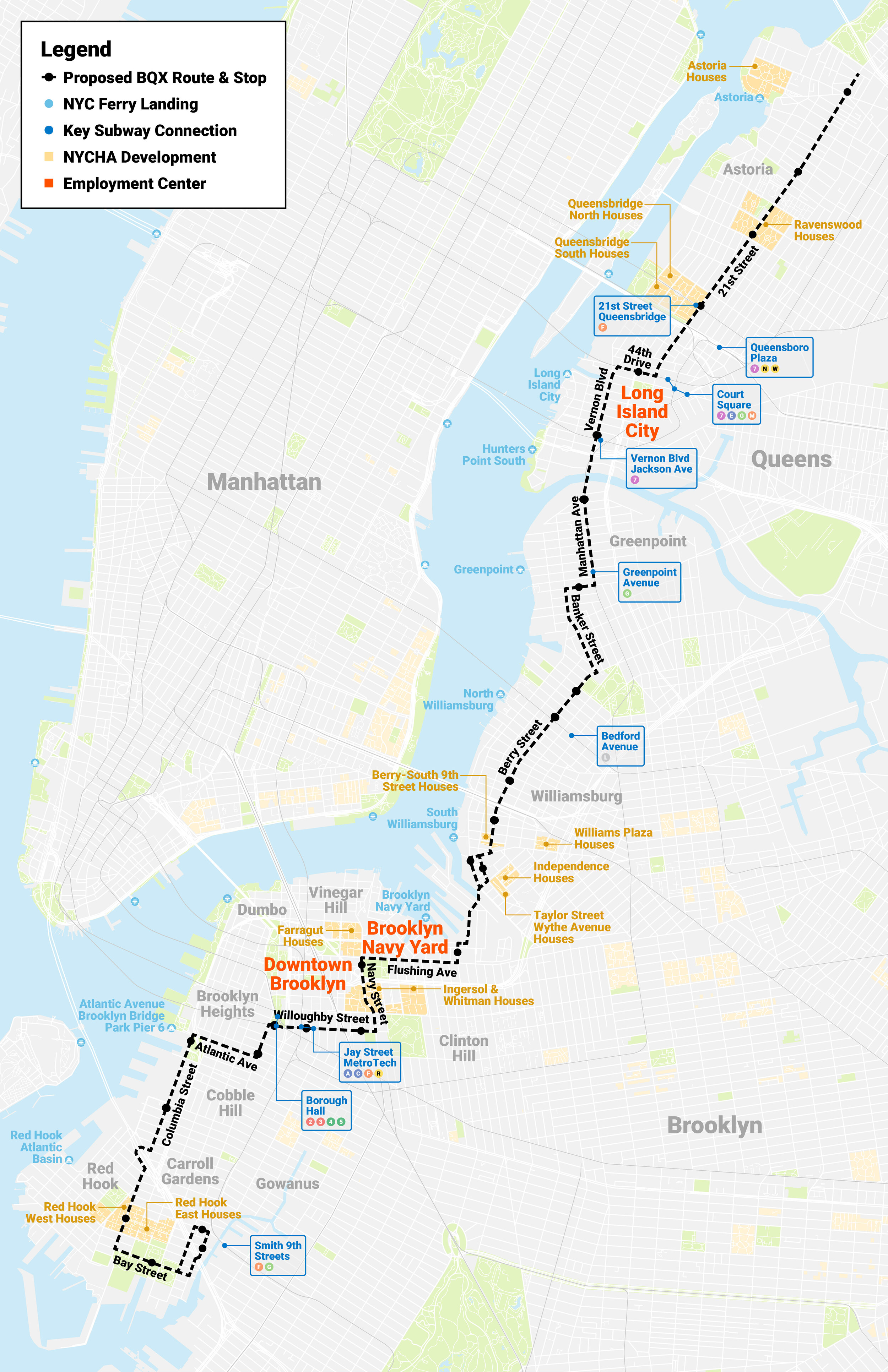
Williamsburg

Key Information

Learn more about the BQX, the current community engagement and environmental review processes, and how it will better connect New Yorkers to where they need to go.

Article image

What is the BQX?

The Brooklyn Queens Connector (BQX) is a City investment to better connect New Yorkers who have limited transit options to where they need to go. The BQX is a proposed streetcar that will connect a dozen neighborhoods along an 11-mile corridor from Red Hook to Astoria. The BQX would be efficient, accessible, resilient and sustainable, and would improve streets in neighborhoods along the corridor.

How would the BQX benefit New Yorkers?

BQX would improve transportation mobility for New Yorkers with limited transit options and introduce a new north-south transit connection between Brooklyn and Queens.

BQX would provide a new transit option for New Yorkers living and working in subway deserts - areas in Astoria, Brooklyn Navy Yard, and Red Hook where subway service is more than a half-mile walk away.

BQX would reduce commute times for people traveling along the corridor and making connections to destinations outside the corridor.

How would the BQX operate?

  • BQX Would Be Efficient

    • An exclusive lane for as much as approximately 90% of the 11-mile route.

    • Short wait times: 5-10 minutes between arrivals during the busiest times.

  • BQX Would Be accessible

    • Boarding areas that match vehicle floor height for fast and ADA-accessible level boarding.

  • BQX Would Be resilient & sustainable

    • Emission-free operations that contribute to NYC’s greenhouse gas reduction goals.
    • Resilient best practices incorporated into design and operations.

  • BQX Would Improve the street experience

    • Traffic calming that aligns with the City’s Vision Zero plan.
    • Improvements to make streets more pedestrian friendly.

What are the next steps in the process?

The City team – led by NYCEDC and NYC DOT – is continuing the community discussion about the route and conducting environmental review to advance the project. Our next steps are:


Public Workshops

To get feedback on the route and discuss process.

February/March 2020

Scoping

To explain what the project is and what will be analyzed.

Public Hearing and Comments

May/June 2020

Draft Environmental Impact Statement (DEIS)

To do an initial, thorough look at potential effects of the project and alternatives.

Public Hearing and Comments

Spring 2021

Final Environmental Impact Statement (FEIS)

To respond to public comments on the analysis and disclose any impacts.

Fall 2021

Future Implementation

• Federal funding

• Franchise authority

• Uniform Land Use Approvals Procedure (ULURP)

• Design-Build-Operate-Maintain (DBOM) entity selection

Contact Us

We want to hear from you.

CONCEPTUAL RENDERING IN RED HOOK